| 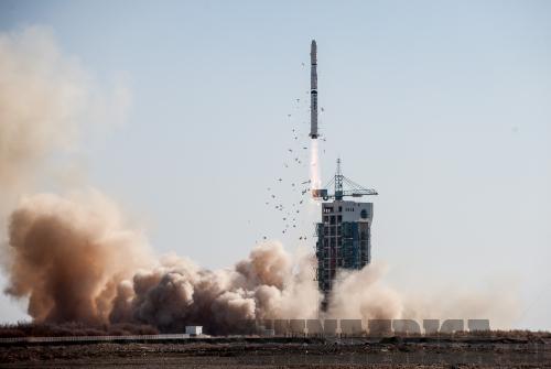
China made headlines at the end of November when it launched the Yaogan XVI into space. In only six years, China has sent 16 of its Yaogan satellites into orbit - yaogan is short for "remote sensing satellite" in Chinese. China's success and progress in remote sensing satellite technology is not just an advancement for China, but has great implications for the world and especially for countries in Africa.
Remote sensing satellites gather information about the earth's surface by measuring electromagnetic radiation. The radiation detected can give information about the chemical and physical makeup of the surface, particularly soil. Thus, satellites like the Yaogan XVI can be used to survey land resources, estimate agricultural yield and prevent and reduce natural disasters. In Africa, remote sensing satellites can be especially useful because of their ability to retrieve soil data.
According to a report by Olivier Dewitte of the European Commission's Joint Research Center, accurate, up-to-date data on soil conditions "are directly applicable to food security planning, flood alleviation and risk assessment and water management."
Remote sensing systems can more efficiently survey the state, characteristic and threat to soil. This is extremely useful in developing early warning systems for droughts, erosion and other natural disasters. Currently in Africa, there are remote sensing systems that have provided in-depth soil maps of different regions. However, these regional maps are often so specialized that they are extremely costly to maintain and also to update; the overload of information makes it difficult to synthesize the data in order to see the continent as a whole.
On the flip side, the Food and Agricultural Organization of the United Nations has a system called ARTEMIS - Africa Real Time Environmental Monitoring Information System. This system provides very low-resolution images via remote sensing satellite, but it is an old system that began in 1988 that has limitations due to its basic technology. In order to have accurate, up-to-date information, Africa needs affordable access to low-resolution data that can be surveyed quickly; it needs satellites that will regularly cover soil resources on the continental level that can then be coordinated with regional data.
China has been a pioneer in using remote sensing satellites to monitor its soil conditions in an accurate and up-to-date fashion that would be useful for African policy-makers. Since the 1990s, Chinese researchers have used remotely sensed large-scale, rough data along with small-scale, detailed data in order to create accurate vegetation and soil maps. This technology has undoubtedly improved since the country has sent its own remote sensing satellites into space and no longer has to rely on remotely sensed data from the West.
As of yet, China does not have immediate plans to help countries in Africa send a remote sensing satellite into space. However, China has made a successful cooperative effort with Nigeria to launch a communication satellite into space in 2007, and in 2011. The project was a landmark for China's satellite export industry as well as for China-Africa cooperation.
It seems that the future of Sino-African cooperation for remote sensing satellites is not far off. Additionally, Chinese researchers may be able to help African researchers use existing remotely sensed data and apply it to soil analysis.
Tech Bytes
» American technology giant Google avoided about $2 billion in worldwide taxes by funneling revenues to a shell company in Bermuda in 2012. Tax loopholes have allowed dozens of tech companies, including Apple, Amazon and Microsoft, to sidestep billions of dollars in taxes. |